Sunday, February 21, 2010

Harbour Town Hilton Head Island, South Carolina

Harbour Town LighthouseA common site when one thinks about Hilton Head. This is the little lighthouse in Harbour Town, a symbol of the Island. Seen often when watching golf from the area. The lighthouse is 90 foot tall, is open as a museum to the public for $5.00. A small gift shop at the base and on top provide shopping opportunities. As you climb the stairs you're viewing the museum items. I'm told this is a good place to watch the sunset. It was about to close the first day we were here, and the 2nd day I tried to tour it; it was closed for maintenance and painting.
Harbour Town Golf LinksHarbour Town Golf Links right on the water's edge is a view you might be familiar with, as it's often shown during competitions on TV. Harbour Town is the toe area of the Island.
shopping in Harbour TownAs you walk the boardwalk you can view the gorgeous ships, soak in the sun (this was one such day), shop in the quaint little village area; or eat at any of the many restaurants. Though we found many restaurants closed during our stay; as it wasn't "in season".
StatueThis, I'm sure is a favorite past-time during the season. The folks you see behind the red rockers are lining up for ice cream. Further down we saw some folks rocking taking in the sun, and a few looked to be taking a nap, while others...like the statue reading a book enjoying the view.
Add to Technorati Favorites
Bookmark and Share

Friday, February 12, 2010

Zion Chapel of East, St. Lukes Parish, Hilton Head, South Carolina

This historic plaque, a bit hard to read indicates this is the site where the historic Zion Chapel of Ease, St. Lukes Parish stood. All that remains is the historic cemetery. Founded in 1767, consecrated in 1833, and destroyed in 1868. Many of the names appearing on these stones tell many stories of Hilton Head Island. In the Pre-Revolutionary War period, the Island was divided into Parishes. This historic cemetery is located on Mathews Drive, named for Phillip Mathews, the first Rector of the Chapel. Specifically it is located on Mathews near Folly Field Road, and William Hilton Parkway--Route 278. I spoke about one of these familes, The Baynard's with regard to The Baynard Ruins.
I have visited and documented many cemeteries, so my reaction to this cemetery came as a surprise. It was dark, damp, and frankly spooky. I've never felt that before when I visited cemeteries. The thick canopy of the tree's keep out the light of day, and the moss hangs low from the trees, somewhat too close to my face for comfort. Grass doesn't seem to grow in this dank atomosphere. Many Revolutionary War Hero's are buried here; and while some of the stones have been replaced and a flag or two were visible; it seemed that many years had passed with little care, and perhaps vandalism. I felt a bit uneasy here, hubby was waiting in the car; so I wasn't alone--but. I didn't know until I returned home and did some research why I had such a uncomfortable feeling.
Mr. Baynard lost his wife from yellow fever, on their wedding day. He was very distraught. His wife died in 1830, his home raided during The Civil War, used as a headquarters for The Union Army and then left in ruins. The Chapel, his chapel abandoned when the plantation owners fled the Union forces to the mainland, destroyed in 1868 by those remaining on the Island in need of the wood--he haunts this land. Yes, this is reported as a haunted location.
moss covered grave stoneMany of the stones are totally covered with moss and lichen and hard to read. Some didn't appear to be readable at all. However, sometimes different light can make a difference in ones' ability to read the stones.

General view
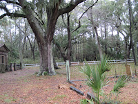
You can see how the tree's canopy adds to the spooky feeling of this little cemetery. It appeared it had been forgotten for quite some time, and then some caring person or group has brought it back.
tree gravestone engulfed by treeThis crooked stone is half eaten by the tree, a site I've seen far too often. It saddens me. Sometimes nothing of the stone can be read when this happens. And sometimes it's a graveyard so forgotten, no one has records to know whom the person or the family that the marker represents was.

Overview of the Island Here
Beach post of the Island here

Tuesday, February 9, 2010

Train Travel

Thomas the Train BookTraveling by train. Yes, actually I've done that. Some years back in Canada with a group of 14 on a ski trip. We did have a sleeping compartment, and...oh wait. That's a post for another time. lol Today, we're traveling by train...Thomas The Train. Look at the expression, he is most certainly traveling somewhere in his imagination. This cutie LOVES all things related to trains and can tell you all the names of Thomas The Train's friends. We hadn't gotten to give him his Christmas presents until a few nights ago.
Thomas the Train PuzzleThis fun large puzzle show's Thomas The Train chugging along, and the flip side of the puzzle can be colored. How cool is that? So cool, he decided hanging upside to show his excitement was a good idea.
Thomas the Train Coloring PuzzleEven coloring, it's hard to catch still enough to get a picture, thus the blur. The special wipe off crayons come with the puzzle.

I think he's traveling to the Island of Sodor to conjure up excitement with Percy, James, and Gordon and friends. Perfect indoor travel for the cold winter months. Right now, we've got about a foot of snow on the ground, (sadly, that makes me think of cold homeless folks). So, indoor train travel is perfect!
Add to Technorati Favorites
Bookmark and Share

Sunday, February 7, 2010

Hilton Head Island, South Carolina, History Part I

Hilton Head Island Map In my first post about Hilton Head Island, the overview, I talked about the shape of the Island being like the shape of the foot. This drawing helps you see that. We stayed about where the A in Atlantic is, so it was a reasonable 3.5 ish miles for me to ride my bike to The Stoney-Baynard Ruins on the bike path. The dot on the far right indicates where the families were buried; but it's quite a bit further and along the highway so I did not travel there on bike.

Baynard Ruins A drawing of the ruins, explaining how the building was made with a method called Tabby. Tabby is made of sea shells that are washed, mixed with sand and fired to form lime. The walls were quite thick, which would have kept the plantation house cool. This is located on the south end of the island in what is now Sea Pines Plantation. The pathway is very much forested, and much of the ruins are hard to see until you're right on top of it. I was alone in the dark woods except for the sounds of birds chirping. A rather strong feeling of excitment and sadness came over me. Excitment because I was standing where history took place. I was standing where a lush plantation once grew, where sadly slaves worked, where Union and Confederate soliders had trod. It was a very moving experience for me.


Baynard Ruins This is what is left of many lives. This chimney, and foundation of what was probably the cellar.


Baynard Ruins You can walk around the ruins, and imagine what had been a grand house. Historians feel this is only the main portion of the main house.

drawing of Baynard RuinsThis is a drawing of what they, the experts believe the house looked like with it's grand steps, cool walk way and entrance to the cellar where the slaves would have stored much of the fruits of their labors, 360 porches where the wealthy plantation owners could view their holdings. Indeed this was a grand house.

slave quarters This drawing depicts what was believed to be slave quarters. Notice the 2 doors and 2 chimneys. This small dwelling would have housed 2 families. Two families living in damp, dark over crowded quarters.
slave quarters Standing at the end of what had been the above slave quarters and looking towards the ruins of man house, you can see how close the buildings are. It is believed this building would have housed the house slaves. The tree stump on the left and what is left of a support log on the right in the center of the ruin was the half way wall, dividing this small building. This small structure measures only 336 square feet. Records indicate 129 slaves were on the plantation in 1850, and probably 20 of those were domestic or house slaves.

tabby This close up of the ruin allows you to see the shells used in the tabby process.
This is must see when you visit Hilton Head. It gives meaning to those that lived and worked the land before us; those people who weren't here for the beach or golf vacation.

Add to Technorati Favorites

Bookmark and Share

Friday, February 5, 2010

Hilton Head, South Carolina, BEACH

beach scene This scene started our day 2. Quite a bit different than the same view the day before. Cool for sure, windy even; but the sun did shine the bulk of the day. BEACH, one of the words I mentioned in the overview to describe Hilton Head is the focus of this post.
beach scene Love the sun reflecting on the beach. This photo was taken from our 4th floor balcony. Sun was nice and warm, but one still needed a wind breaker on, long pants and real shoes. I wore a headband to keep the wind out of my ears most of the day, as I rode my bike about the Island. More on bike tour later.

Stars and Stripes Look carefully at the name on the folded sail...remember clicking on the pictures makes them larger. STARS and STRIPES! Seriously. Beach and water front activities are in abundance here on the island...just not recommended for this time of the year. You can rent Stars and Stripes and go sailing. This is the 12 meter America's Cup, available for rental here on the island. Kayaks, cruising, touring via cruise ships also are available. In season dinner sunset tours are available. It's fun to stroll any of the dock areas and see the ships...some I'm sure are owned by the rich and famous. Harbour town is the dock where Stars and Stripes is located. Harbour town is one of the many sections on the island. The island is shaped like a foot, with Harbour town being the toe area. The original plantation names still help you find your way about the island. Each area, each plantation is private and one needs a pass to enter, though saying you're playing golf is really all the gatekeeper expects most folks to say before he let's them enter. Each area has it's own shopping area, resturants, and villas/condos/resorts and bike rental. The landscaping is such that you can be right beside something and really not see it. So shopping in your own little area is adviseable and easier.
sunset This is our first sunset, which occured on day 2, just before dinner. We decided to take a walk on the beach and watch the sunset. That's not usual beach attire I'm wearing. Headband for the ears, all weather type vest under my windbreaker/raincoat....and gloves!
sunset The sunset was beautiful that night, despite the cold. This is one of 2 trees in our walking distance that had washed ashore.