Tuesday, February 9, 2010

Train Travel

Thomas the Train BookTraveling by train. Yes, actually I've done that. Some years back in Canada with a group of 14 on a ski trip. We did have a sleeping compartment, and...oh wait. That's a post for another time. lol Today, we're traveling by train...Thomas The Train. Look at the expression, he is most certainly traveling somewhere in his imagination. This cutie LOVES all things related to trains and can tell you all the names of Thomas The Train's friends. We hadn't gotten to give him his Christmas presents until a few nights ago.
Thomas the Train PuzzleThis fun large puzzle show's Thomas The Train chugging along, and the flip side of the puzzle can be colored. How cool is that? So cool, he decided hanging upside to show his excitement was a good idea.
Thomas the Train Coloring PuzzleEven coloring, it's hard to catch still enough to get a picture, thus the blur. The special wipe off crayons come with the puzzle.

I think he's traveling to the Island of Sodor to conjure up excitement with Percy, James, and Gordon and friends. Perfect indoor travel for the cold winter months. Right now, we've got about a foot of snow on the ground, (sadly, that makes me think of cold homeless folks). So, indoor train travel is perfect!
Add to Technorati Favorites
Bookmark and Share

Sunday, February 7, 2010

Hilton Head Island, South Carolina, History Part I

Hilton Head Island Map In my first post about Hilton Head Island, the overview, I talked about the shape of the Island being like the shape of the foot. This drawing helps you see that. We stayed about where the A in Atlantic is, so it was a reasonable 3.5 ish miles for me to ride my bike to The Stoney-Baynard Ruins on the bike path. The dot on the far right indicates where the families were buried; but it's quite a bit further and along the highway so I did not travel there on bike.

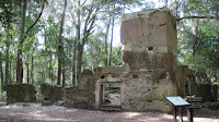
Baynard Ruins A drawing of the ruins, explaining how the building was made with a method called Tabby. Tabby is made of sea shells that are washed, mixed with sand and fired to form lime. The walls were quite thick, which would have kept the plantation house cool. This is located on the south end of the island in what is now Sea Pines Plantation. The pathway is very much forested, and much of the ruins are hard to see until you're right on top of it. I was alone in the dark woods except for the sounds of birds chirping. A rather strong feeling of excitment and sadness came over me. Excitment because I was standing where history took place. I was standing where a lush plantation once grew, where sadly slaves worked, where Union and Confederate soliders had trod. It was a very moving experience for me.


Baynard Ruins This is what is left of many lives. This chimney, and foundation of what was probably the cellar.


Baynard Ruins You can walk around the ruins, and imagine what had been a grand house. Historians feel this is only the main portion of the main house.

drawing of Baynard RuinsThis is a drawing of what they, the experts believe the house looked like with it's grand steps, cool walk way and entrance to the cellar where the slaves would have stored much of the fruits of their labors, 360 porches where the wealthy plantation owners could view their holdings. Indeed this was a grand house.

slave quarters This drawing depicts what was believed to be slave quarters. Notice the 2 doors and 2 chimneys. This small dwelling would have housed 2 families. Two families living in damp, dark over crowded quarters.
slave quarters Standing at the end of what had been the above slave quarters and looking towards the ruins of man house, you can see how close the buildings are. It is believed this building would have housed the house slaves. The tree stump on the left and what is left of a support log on the right in the center of the ruin was the half way wall, dividing this small building. This small structure measures only 336 square feet. Records indicate 129 slaves were on the plantation in 1850, and probably 20 of those were domestic or house slaves.

tabby This close up of the ruin allows you to see the shells used in the tabby process.
This is must see when you visit Hilton Head. It gives meaning to those that lived and worked the land before us; those people who weren't here for the beach or golf vacation.

Add to Technorati Favorites

Bookmark and Share

Friday, February 5, 2010

Hilton Head, South Carolina, BEACH

beach scene This scene started our day 2. Quite a bit different than the same view the day before. Cool for sure, windy even; but the sun did shine the bulk of the day. BEACH, one of the words I mentioned in the overview to describe Hilton Head is the focus of this post.
beach scene Love the sun reflecting on the beach. This photo was taken from our 4th floor balcony. Sun was nice and warm, but one still needed a wind breaker on, long pants and real shoes. I wore a headband to keep the wind out of my ears most of the day, as I rode my bike about the Island. More on bike tour later.

Stars and Stripes Look carefully at the name on the folded sail...remember clicking on the pictures makes them larger. STARS and STRIPES! Seriously. Beach and water front activities are in abundance here on the island...just not recommended for this time of the year. You can rent Stars and Stripes and go sailing. This is the 12 meter America's Cup, available for rental here on the island. Kayaks, cruising, touring via cruise ships also are available. In season dinner sunset tours are available. It's fun to stroll any of the dock areas and see the ships...some I'm sure are owned by the rich and famous. Harbour town is the dock where Stars and Stripes is located. Harbour town is one of the many sections on the island. The island is shaped like a foot, with Harbour town being the toe area. The original plantation names still help you find your way about the island. Each area, each plantation is private and one needs a pass to enter, though saying you're playing golf is really all the gatekeeper expects most folks to say before he let's them enter. Each area has it's own shopping area, resturants, and villas/condos/resorts and bike rental. The landscaping is such that you can be right beside something and really not see it. So shopping in your own little area is adviseable and easier.
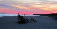
sunset This is our first sunset, which occured on day 2, just before dinner. We decided to take a walk on the beach and watch the sunset. That's not usual beach attire I'm wearing. Headband for the ears, all weather type vest under my windbreaker/raincoat....and gloves!
sunset The sunset was beautiful that night, despite the cold. This is one of 2 trees in our walking distance that had washed ashore.

Thursday, February 4, 2010

Hilton Head Island, South Carolina, OVERVIEW

icy windshieldcloudy beach view
The first words I thought of to describe Hilton Head Island prior to planning a trip there were:
Expensive
Rich and famous
Golf
There is so much more to the island than what those words can describe. So much so I will make a post for each of the words I now think of to relate to Hilton Head Island such as:Golf,History,Environment,Food,Rich and famous, Beach***in no particular order of importance. It took some doing to get here. We ran into an unexpected snow storm in our travels and altered our accommodations on the way down as a result. Hubby's booked his golf around the weather and our site seeing also revolved around the weather. Thankfully I got lots of pictures to share with you BEFORE the camera broke. This is very upsetting to me. The camera is new, only a few months old. I'm hopeful it can be returned when we get back home.

The island is relatively new...new in terms of what we all think of that is. The vacation spot, the golfers paradise haven't been around all that long. Electricity only got to the island back in 1950 so you can see what I mean.

The short history is the area was initially inhabited by Native American tribes, then the Spanish arrived (back in the 1500's). The Spanish mistreated the natives and were ousted by them. Along came the English, Captain William Hilton in search of land to grow sugar cane and indigo. Plantations flourished.

The Island was over run with Union forces during The Civil War, Confederate prisoners, and escaped slaves. After the war, the island was all but abandoned. The crops were destroyed by the Boll Weevil and the people who remained were escaped slaves and their descendants. They fished and farmed in isolation; not being connected to the mainland. They developed their own language and culture based on their African heritage. It wasn't until 1940 the island was re-discovered by wealthy sportsmen, who saw the commercial potential of all the Pine Trees. In 1950 electricity hit the island and in 1956 the bridge connecting it to the mainland made transportation to and from the island more accessible; thus the period of tourism began in earnest. Charles Fraser's family owned a large portion of the island (specifically the area now called Sea Pines). He was a lover of nature and forward thinking with development. Though the island is commercialized, and highly developed; it is done so with protectionism for the land in mind. Buildings, signs, lights etc. all must meet a strict environmental standard. Large areas of land are put aside as a preserve for the birds, alligators and turtles. Even lights from the hotels are regulated during important nesting times.

The island is 12 miles long and 5 miles wide, with lots of bike trails, beaches, golf courses, and nature preserves. Charles Fraser is buried under an Oak Tree on the island he so loved. Much is still being learned about the Gullah culture (the culture of the slaves and their descendants), which no doubt will add to what we know about Hilton Head Island.

The photo's show our less than pleasant drive here, and the cloudy beach when we first arrived.

Add to Technorati Favorites
Bookmark and Share

Wednesday, February 3, 2010

Cape Cod Lighthouse, Massachusettes

Cape Cod Lighthouse Cape Cod Lighthouse (Highland Light), is the oldest of the lighthouses in Cape Cod. It's tower is 66 feet, on a hill 130 feet above the beach. A wonderful lighthouse museum can be toured for a small fee. Over time erosion shortened the distance the lighthouse was from the shore. A severe winter storm in 1996 took away 40 feet; causing great concern. The following summer the lighthouse was moved back to a safer distance.
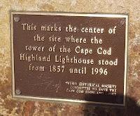
lighthouse plaque This plaque indicates the exact location of the original lighthouse.

Add to Technorati Favorites
Bookmark and Share

Sunday, January 31, 2010

Bunker Hill, Boston Massachusetts

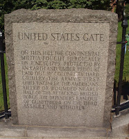
Colonel William Prescott StatureBoston Harbor viewBunker Hill  Gate
Colonel William Prescott's statue welcomes yous after you climb Breeds Hill where The Bunker Hill Memorial is located. The Battle of Bunker Hill was the first major battle of The American Revolution. The bulk of the battle took place on Breeds Hill, rather than Bunker Hill and thus is known by the wrong name. The Colonists were far out numbered, but suffered fewer causalities in the battle. Though the battle was ultimately won by The British, The American Colonists inflicted large numbers of causalities in their forces (in fact almost 50%), repealing them successfully in the first 2 rounds of battle.

"Don't Fire Until You See The Whites of Their Eyes!", a famous quote that perhaps tells why The Colonist did so well under the direction of Colonel William Prescott.

The impressive granite obelisk stands 221 feet. Hubby and I climbed the 294 steps to the top of memorial in the oppressive summer heat to see the view. Our traveling compions whimped out and sat waiting impatiently for us. The view is through the window and so even when you reached the top, there is no air. I did find the closeness a bit difficult.

If you look carefully you can see The US Constitution behind the red brick building their in the harbor.

The monument is open to the public daily from 9-5 except holidays and is FREE. They do stop the line (if there is one) at 4:30 to allow people time to climb and down those 294 steps. It's a tight winding stairway and not suitable for small children, or adults with breathing or walking difficulties; as there is no where to rest.

I'm hopeful to return to this area in Boston to explore more; but not with the same inpatient traveling companions.

Add to Technorati Favorites
Bookmark and Share

Friday, January 29, 2010

Arlington National Cemetery, Virginia

rows of marble gravestonesRow on row of gravestones, an impressive site with the white marble glistening bright reflecting the heat of the day. And hot it was, most of the grass no longer green scorched from the extreme temperatures. We did our best to go the distance between the trolley and walking to see and feel as much as we could. The feeling you get is hard to describe; but something I believe everyone should experience. Let me suggest you go though not in the August heat.
James Richmond Medal of Honor HeadstoneShade inches up on Pvt. James Richmond's gravestone (far left front row), a fellow Ohioan who captured The Flag at Gettysburg while serving in Co. F. 8th Ohio Infantry on that fateful day on June 3, 1864. A Medal of Honor Recipient, who gave his all; as so many did. 4 Million visitors annually visit Arlington. 200 acres filled with people to be remembered and honored. Park you car, walk or ride the tour bus; driving in the cemetery is only allowed with special permission for funerals. Visit the visitors center and obtain a map to help you plan your path.
Memorial Amphitheater Arlington National CemeteryThis is The Memorial Amphitheater where special ceremonies are held on Easter, Memorial Day, and Veterans Day. Thousands attend these special ceremonies. 44 US Battles from The American Revolution through The Spanish American War are inscribed around the freize above the colonnade
Kennedy GravestonesThe Eternal Flame, President John F. Kennedy's final resting place, that of his wife and 2 of his children. It's very difficult to obtain a decent picture because everyone wants to be there. What I found terribly troubling was the lack of quiet reference I believe should have existed. I've discussed this with others who toured here at Arlington. They experienced the same, rudeness really. People want pictures, pushing and shoving in some cases to get where they felt they had a right to be. I was filled with such emotion, remembering his being assassinated. Remembering where I was when I heard the horrible news. And so, I stood here on the side and took my photo at these unpretentious graves.

Tomb of The UnknownProbably no one needs me to say this is the changing of the guard at The Tomb of The Unknown Soldier. A very very impressive site, watching the precision and the dedication shown by these guards. The Tomb is in need of repair from the elements and places are worn from the guards movements. The 3rd Infantry, The Old Guard has this very high honor 365 days a year through all kinds of weather.

The first graves were dug by James Parks, a former slave at Arlington House. He is the only person buried at Arlington who was born there.

The history of those that served spans far and wide and touches many of our family trees. A separate history of Arlington House, as well as a separate tour awaits those with stamina when they get to the top of the hill. Thought many say it was Robert E. Lee's house that's not technically correct. It belonged to his wife's family. Pvt. William Henry Christman of the 67th Pennsylvania Infantry was the first military burial. It was thought if Union Soldiers were buried on the estate of Robert E. Lee, he could not and would not ever return.

I highly recommend spending time, lots of time here. Come prepared with sunscreen, water, and walking shoes. While I think children need to experience this, I also suggest it's not suited for young children who need to run and yell. Parents need to prepare children for what they will see and experience so proper respect can be shown. I do hope to return for another visit, in cooler temperatures.
Add to Technorati FavoritesBookmark and Share